Your Cart is Empty

FLORIDA EAST COAST MARINE WEATHER
High pressure will drift east through Wednesday. A cold front will cross the area Thursday evening. Strong to possibly severe t-storms are expected along and ahead of the frontal boundary in the afternoon. Seasonally cool/dry high pressure will build from the west Friday, pass overhead Saturday, then move east out into the Atlantic Sunday through Monday.
7-DAY SURF FORECAST
TUESDAY: Wind calm to light south in the morning, then SE 7-14 mph late morning through the afternoon with waves 1-1.5′ (occ 2′ at times) in moderate to occ/inc long period (9-occ 10 sec) ENE/E swell.
WEDNESDAY(10Apr):Wind lightest from the SSWS in the morning, becoming SSE 12-18 mph in the afternoon with waves 1-occ 2′ (+/-0.5′) in close to moderate period (5-9 sec) east mix swell.
THURSDAY: Wind ramping up from the south 15-23 mph with surf building to 2-2.5′ (+/-0.5′) in close to moderate period (6-7 sec) SE “suck-up” swell. Wind may clock offshore late in the afternoon following progression of the broken line of showers and t-storms (a few potentially severe) pushing rapidly across the coast into the Atlantic north of the Cape.
FRIDAY: Wind W/WNW 7-14 mph with waves starting out at 1-2′ (+/-0.5′) in moderate period (7-8 sec) lingering SE swell, shedding size and consistency as the day wears on.
SATURDAY(13Apr): Wind light NW early, then NW/N 6-13 mph with waves dropping down to 1-occ 1.5′ (+/-0.5′) in moderate period (8 sec) mixed easterly swell.
SUNDAY:
MONDAY:
7-10 DAY WEATHER OUTLOOK (with Hurricane Season Outlook)
The first 10 days in April will see generally very small surf. Around mid-month, models have been flip-flopping on a strong low spinning up in the north/central Atlantic combining with a strong high pressure ridge building across the sub-tropical Atlantic. If this pans out, we should see an increase in NE/E swell building to 1.5-2.5′ as the Atlantic high-pressure ridge strengthens and lengthens the ENE fetch. CSU’s forecast for an active hurricane season: 2024 Tropical Forecast. Surf temps north of the Cape will slowly climb out of through the mid-to-upper 60’sF through mid-April, finally reaching the “magical” 70F-degree mark (for good!) later in the month … stay tuned!
“The ocean is a desert with its life underground, and the perfect disguise up above.” America- A Horse with no Name.
NWS Coastal Waters/Weather Forecast Links
St. Augustine to Flagler Beach
NWS Jacksonville Coastal Forecast
NOAA upgrading nearshore wave prediction.
7-day St. Augustine buoy sea height forecast (primary swell).
Florida Coastal Forecast Map (click on zone)
Marine Page for SE Georgia/NE Florida
_________________________________________________________________________________________
This graph illustrates the 14-day forecast for primary swell height and period for the St. Augustine offshore buoy:
St Augustine buoy 14-day forecast
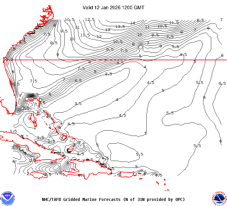
This map illustrates sea height contour (in feet) for the near shore Atlantic Ocean east of Florida:

 ______________________________________________________________________________________________________
Sea surface temps in the GOMEX and western Caribbean Sea.
Watch this GOES loop for lightning signatures that indicate intense convection.
______________________________________________________________________________________________________
The NHC Atlantic Tropical Weather Discussion and the tropical western Atlantic satellite loop are good tools to monitor the Atlantic basin for activity. Good links (updated regularly) to excellent private websites with forecast discussions monitoring tropical and non-tropical weather impacting Florida and the eastern US: Central Florida Hurricane Center and WeatherBELL
Here is a link to the impact hurricane activity has on our coast: Florida beaches face sand shortage
El Nino Southern Oscillation (ENSO) Discussion